|
| Home → WINDEV 25 → WX Informatica - Exemplo de Google Maps com Json retornando Distancia, Tempo e Rota |
| WX Informatica - Exemplo de Google Maps com Json retornando Distancia, Tempo e Rota |
| Started by BOLLER, Feb., 16 2018 11:14 PM - 8 replies |
| |
| | | |
|
| |
Registered member
3,657 messages
Popularité : +175 (223 votes) |
|
Posted on February, 16 2018 - 11:14 PM |
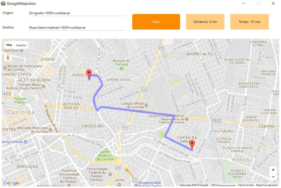
Prezados,
Segue abaixo Exemplo de Google Maps com Json retornando Distancia, Tempo e Rota
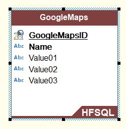
Exemplo Usando uma tabela HFSQL
code:wl]
GLOBAL
gloLatitudeOrigem, gloLongitudeOrigem, gloLatitudeDestino, gloLongitudeDestino, grDistancia, grTempo is real
ST_GoogleMaps is Structure
sGoogleMapsName is string
sGoogleMapsValue is string
END
arrGoogle is array of 5000 ST_GoogleMaps
[/code]
Procedure GoogleMapsRotaTable(Origem, Destino, XmlJson)
PersonalJson is Variant
XmlJsonResultado is string
IF Origem <> "" AND Destino = "" THEN
Destino = Origem
END
ok is boolean = False
IF Origem <> "" AND Destino <> ""
ChangeCharset(charsetOccidental)
Origem = Capitalize(NoAccent(Origem))
Origem = Replace(Origem," ","+")
Destino = Capitalize(NoAccent(Destino))
Destino = Replace(Destino," ","+")
HTTPCreateForm("GoogleMaps")
HTTPAddParameter("GoogleMaps","origin", Origem)
HTTPAddParameter("GoogleMaps","destination", Destino)
HTTPAddParameter("GoogleMaps","language", "pt-BR")
HTTPAddParameter("GoogleMaps","region", "br")
HTTPAddParameter("GoogleMaps","units", "metric")
HTTPAddParameter("GoogleMaps","key","AIzaSyDbSVKYPwB1a-_vPbDzAr6LgAfIj4iW2hc")
cMyRequest is a httpRequest
IF Upper(XmlJson) = "XML"
cMyRequest..URL = "https://maps.googleapis.com/maps/api/directions/xml"
ELSE IF Upper(XmlJson) = "JSON"
cMyRequest..URL = "https://maps.googleapis.com/maps/api/directions/json"
END
cMyRequest..Method = httpGet
cMyResponse is a httpResponse = HTTPSendForm("GoogleMaps", cMyRequest)
IF cMyResponse..StatusCode <> 200 THEN
XmlJsonResultado = "Erro"
ELSE
PersonalJson = JSONToVariant(cMyResponse.Content)
HDeleteAll(GoogleMaps)
GoogleMaps.Name = "Status"
GoogleMaps.Value01 = PersonalJson.routes[1].geocoder_status
HAdd(GoogleMaps)
GoogleMaps.Name = "Latitude Norte"
GoogleMaps.Value01 = PersonalJson.routes[1].bounds.northeast.lat..Value
HAdd(GoogleMaps)
GoogleMaps.Name = "Longitude Norte"
GoogleMaps.Value01 = PersonalJson.routes[1].bounds.northeast.lng..Value
HAdd(GoogleMaps)
GoogleMaps.Name = "Latitude Sul"
GoogleMaps.Value01 = PersonalJson.routes[1].bounds.southwest.lat..Value
HAdd(GoogleMaps)
GoogleMaps.Name = "Longitude Sul"
GoogleMaps.Value01 = PersonalJson.routes[1].bounds.southwest.lng..Value
HAdd(GoogleMaps)
GoogleMaps.Name = "Distancia Texto Total"
GoogleMaps.Value01 = PersonalJson.routes[1].legs[1].distance.text..Value
HAdd(GoogleMaps)
GoogleMaps.Name = "Distancia Valor Total"
GoogleMaps.Value01 = PersonalJson.routes[1].legs[1].distance.value..Value
grDistancia = GoogleMaps.Value01
HAdd(GoogleMaps)
GoogleMaps.Name = "Duracao Texto Total"
GoogleMaps.Value01 = PersonalJson.routes[1].legs[1].duration.text..Value
HAdd(GoogleMaps)
GoogleMaps.Name = "Duracao Valor Total"
GoogleMaps.Value01 = PersonalJson.routes[1].legs[1].duration.value..Value
grTempo = GoogleMaps.Value01
HAdd(GoogleMaps)
GoogleMaps.Name = "Endereço Completo Inicial"
GoogleMaps.Value01 = PersonalJson.routes[1].legs[1].start_address..Value
HAdd(GoogleMaps)
GoogleMaps.Name = "Endereço Inicial Latitude"
GoogleMaps.Value01 = PersonalJson.routes[1].legs[1].start_location.lat..Value
gloLatitudeOrigem = GoogleMaps.Value01
HAdd(GoogleMaps)
GoogleMaps.Name = "Endereço Inicial Longitude"
GoogleMaps.Value01 = PersonalJson.routes[1].legs[1].start_location.lng..Value
gloLongitudeOrigem = GoogleMaps.Value01
HAdd(GoogleMaps)
GoogleMaps.Name = "Endereço Completo Final"
GoogleMaps.Value01 = PersonalJson.routes[1].legs[1].end_address..Value
HAdd(GoogleMaps)
GoogleMaps.Name = "Endereço Final Latitude"
GoogleMaps.Value01 = PersonalJson.routes[1].legs[1].end_location.lat..Value
gloLatitudeDestino = GoogleMaps.Value01
HAdd(GoogleMaps)
GoogleMaps.Name = "Endereço Final Longitude"
GoogleMaps.Value01 = PersonalJson.routes[1].legs[1].end_location.lng..Value
gloLongitudeDestino= GoogleMaps.Value01
HAdd(GoogleMaps)
i is int = 0
FOR EACH x OF PersonalJson.routes[1].legs[1].steps
i+= 1
GoogleMaps.Name = "Step ["+ i +"]"
HAdd(GoogleMaps)
GoogleMaps.Name = "Step ["+ i +"] Latitude Inicial"
GoogleMaps.Value01 = PersonalJson.routes[1].legs[1].steps[i].start_location.lat
HAdd(GoogleMaps)
GoogleMaps.Name = "Step ["+ i +"] Longitude Inicial"
GoogleMaps.Value01 = PersonalJson.routes[1].legs[1].steps[i].start_location.lng
HAdd(GoogleMaps)
GoogleMaps.Name = "Step ["+ i +"] Latitude Final"
GoogleMaps.Value01 = PersonalJson.routes[1].legs[1].steps[i].end_location.lat
HAdd(GoogleMaps)
GoogleMaps.Name = "Step ["+ i +"] Longitude Final"
GoogleMaps.Value01 = PersonalJson.routes[1].legs[1].steps[i].end_location.lng
HAdd(GoogleMaps)
GoogleMaps.Name = "Step ["+ i +"] Distancia text"
GoogleMaps.Value01 = PersonalJson.routes[1].legs[1].steps[i].distance.text
HAdd(GoogleMaps)
GoogleMaps.Name = "Step ["+ i +"] Distancia value"
GoogleMaps.Value01 = PersonalJson.routes[1].legs[1].steps[i].distance.value
HAdd(GoogleMaps)
GoogleMaps.Name = "Step ["+ i +"] Duracao text"
GoogleMaps.Value01 = PersonalJson.routes[1].legs[1].steps[i].duration.text
HAdd(GoogleMaps)
GoogleMaps.Name = "Step ["+ i +"] Duracao value"
GoogleMaps.Value01 = PersonalJson.routes[1].legs[1].steps[i].duration.value
HAdd(GoogleMaps)
GoogleMaps.Name = "Step ["+ i +"] Instruções de Voz"
GoogleMaps.Value01 = PersonalJson.routes[1].legs[1].steps[i].html_instructions
HAdd(GoogleMaps)
GoogleMaps.Name = "Step ["+ i +"] Points Polyline Endcode Google"
GoogleMaps.Value01 = PersonalJson.routes[1].legs[1].steps[i].polyline.points
HAdd(GoogleMaps)
GoogleMaps.Name = "Step ["+ i +"] Travel Mode"
GoogleMaps.Value01 = PersonalJson.routes[1].legs[1].steps[i].travel_mode
HAdd(GoogleMaps)
END
END
XmlJsonResultado = "OK"
ELSE
XmlJsonResultado = "Erro"
END
RESULT(XmlJsonResultado)
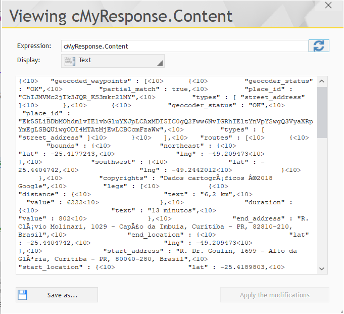
Resultado Json apos o Httprequest
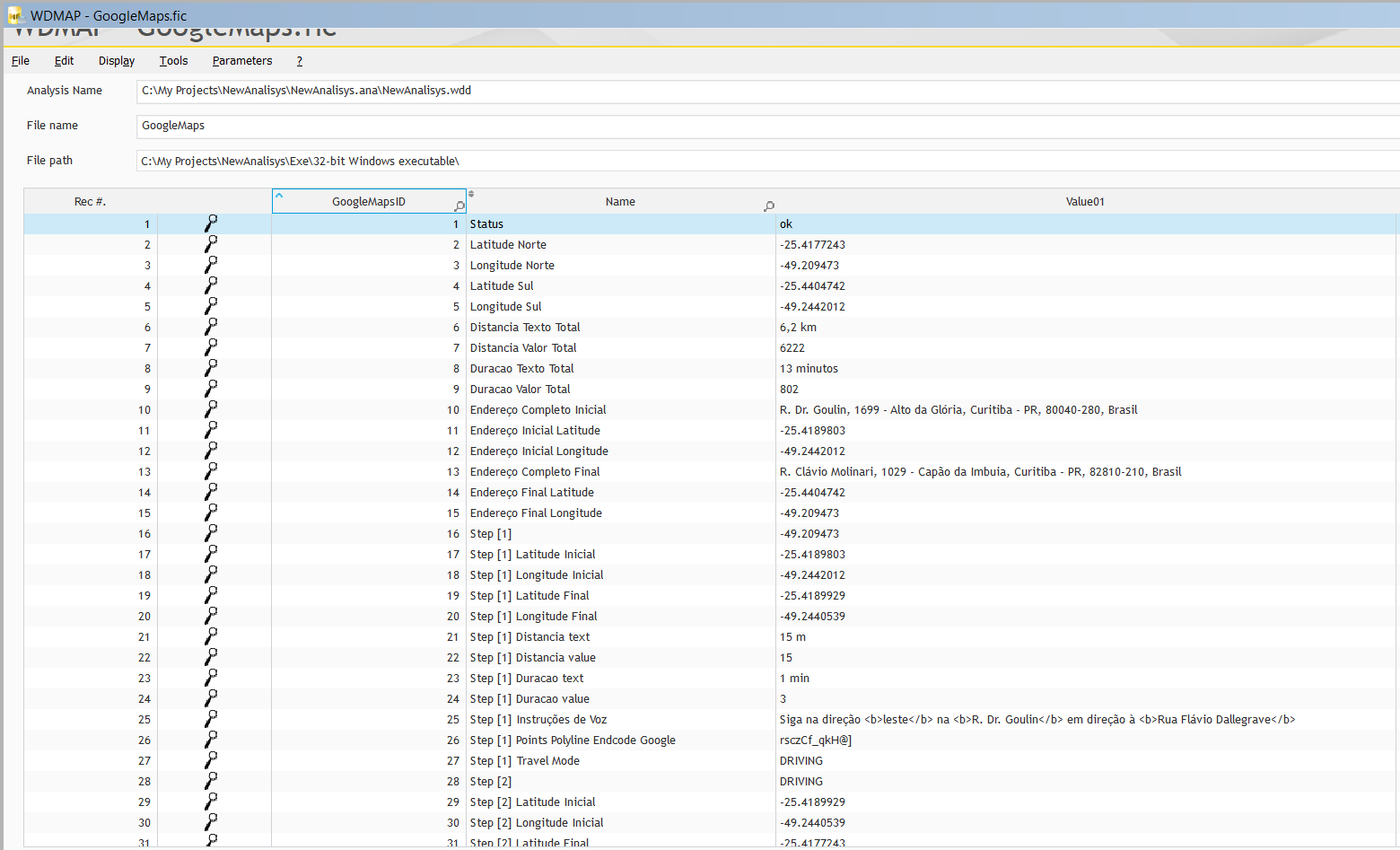
Resultado após a importação do json para Hfsql
CODIGO DO BOTAO
GoogleMapsRotaTable(EDT_Origem,EDT_Destino,"JSON")
POrigem is geoPosition
POrigem..Latitude = gloLatitudeOrigem
POrigem..Longitude = gloLongitudeOrigem
MarkerOrigem is Marker
MarkerOrigem..Position = POrigem
MarkerOrigem..Name = "Origem"
MarkerOrigem..Description = "Origem"
MapAddMarker(MAP_GoogleMaps,MarkerOrigem)
PDestino is geoPosition
PDestino..Latitude = gloLatitudeDestino
PDestino..Longitude = gloLongitudeDestino
MarkerDestino is Marker
MarkerDestino..Position = PDestino
MarkerDestino..Name = "Destino"
MarkerDestino..Description = "Destino"
MapAddMarker(MAP_GoogleMaps,MarkerDestino)
MapAddItinerary(MAP_GoogleMaps,[POrigem,PDestino],itineraryCar)
BTN_DISTANCIA..Text = "Distancia: "+grDistancia+" km"
BTN_TEMPO..Text = "Tempo: "+grTempo+" min"
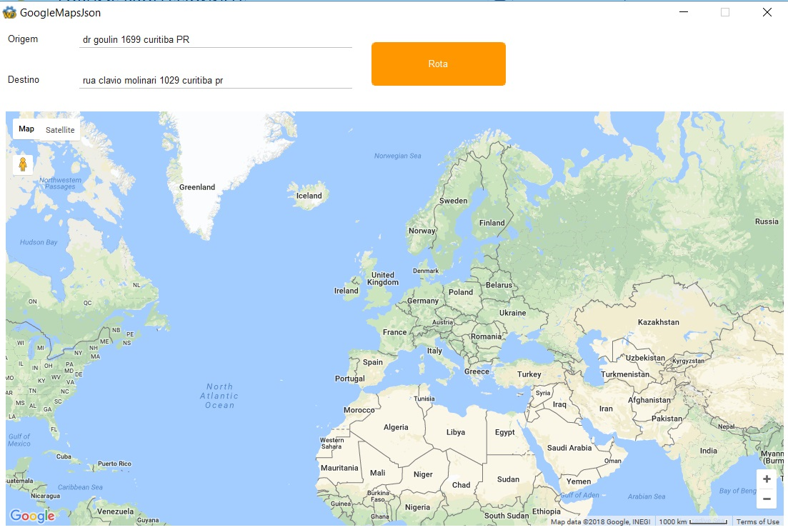
RESULTADO FINAL
--
Adriano José Boller
______________________________________________
Consultor e Representante Oficial da
PcSoft no Brasil
+55 (41) 99949 1800
adrianoboller@gmail.com
skype: adrianoboller
http://wxinformatica.com.br/Message modified, February, 17 2018 - 12:23 AM |
| |
| |
| | | |
|
| | |
| |
Registered member
3,657 messages
Popularité : +175 (223 votes) |
|
Posted on February, 16 2018 - 11:22 PM |
{<10> "geocoded_waypoints" : [<10> {<10> "geocoder_status" : "OK",<10> "partial_match" : true,<10> "place_id" : "ChIJMVMc2jTk3JQR_KS3mkr2lMY",<10> "types" : [ "street_address" ]<10> },<10> {<10> "geocoder_status" : "OK",<10> "place_id" : "Ek5SLiBDbMOhdmlvIE1vbGluYXJpLCAxMDI5IC0gQ2Fww6NvIGRhIEltYnVpYSwgQ3VyaXRpYmEgLSBQUiwgODI4MTAtMjEwLCBCcmFzaWw",<10> "types" : [ "street_address" ]<10> }<10> ],<10> "routes" : [<10> {<10> "bounds" : {<10> "northeast" : {<10> "lat" : -25.4177243,<10> "lng" : -49.209473<10> },<10> "southwest" : {<10> "lat" : -25.4404742,<10> "lng" : -49.2442012<10> }<10> },<10> "copyrights" : "Dados cartográficos ©2018 Google",<10> "legs" : [<10> {<10> "distance" : {<10> "text" : "6,2 km",<10> "value" : 6222<10> },<10> "duration" : {<10> "text" : "13 minutos",<10> "value" : 802<10> },<10> "end_address" : "R. Clávio Molinari, 1029 - Capão da Imbuia, Curitiba - PR, 82810-210, Brasil",<10> "end_location" : {<10> "lat" : -25.4404742,<10> "lng" : -49.209473<10> },<10> "start_address" : "R. Dr. Goulin, 1699 - Alto da Glória, Curitiba - PR, 80040-280, Brasil",<10> "start_location" : {<10> "lat" : -25.4189803,<10> "lng" : -49.2442012<10> },<10> "steps" : [<10> {<10> "distance" : {<10> "text" : "15 m",<10> "value" : 15<10> },<10> "duration" : {<10> "text" : "1 min",<10> "value" : 3<10> },<10> "end_location" : {<10> "lat" : -25.4189929,<10> "lng" : -49.2440539<10> },<10> "html_instructions" : "Siga na direção \u003cb\u003eleste\u003c/b\u003e na \u003cb\u003eR. Dr. Goulin\u003c/b\u003e em direção Ã<SPC> \u003cb\u003eRua Flávio Dallegrave\u003c/b\u003e",<10> "polyline" : {<10> "points" : "rsczCf_qkH@]"<10> },<10> "start_location" : {<10> "lat" : -25.4189803,<10> "lng" : -49.2442012<10> },<10> "travel_mode" : "DRIVING"<10> },<10> {<10> "distance" : {<10> "text" : "0,1 km",<10> "value" : 144<10> },<10> "duration" : {<10> "text" : "1 min",<10> "value" : 47<10> },<10> "end_location" : {<10> "lat" : -25.4177243,<10> "lng" : -49.2437741<10> },<10> "html_instructions" : "Vire Ã<SPC> \u003cb\u003eesquerda\u003c/b\u003e na \u003cb\u003eR. Pres. Rodrigo Otávio\u003c/b\u003e",<10> "maneuver" : "turn-left",<10> "polyline" : {<10> "points" : "tsczCh~pkHUGa@Ka@G[Eq@IuAK"<10> },<10> "start_location" : {<10> "lat" : -25.4189929,<10> "lng" : -49.2440539<10> },<10> "travel_mode" : "DRIVING"<10> },<10> {<10> "distance" : {<10> "text" : "0,3 km",<10> "value" : 266<10> },<10> "duration" : {<10> "text" : "1 min",<10> "value" : 54<10> },<10> "end_location" : {<10> "lat" : -25.4179433,<10> "lng" : -49.2411403<10> },<10> "html_instructions" : "Vire Ã<SPC> \u003cb\u003edireita\u003c/b\u003e na 1ª rua transversal para \u003cb\u003eR. Augusto Stresser\u003c/b\u003e",<10> "maneuver" : "turn-right",<10> "polyline" : {<10> "points" : "vkczCp|pkHD_@@[@Y@S@U@e@@K@o@@UDy@@a@HsB@a@@c@"<10> },<10> "start_location" : {<10> "lat" : -25.4177243,<10> "lng" : -49.2437741<10> },<10> "travel_mode" : "DRIVING"<10> },<10> {<10> "distance" : {<10> "text" : "1,3 km",<10> "value" : 1288<10> },<10> "duration" : {<10> "text" : "2 minutos",<10> "value" : 128<10> },<10> "end_location" : {<10> "lat" : -25.4282871,<10> "lng" : -49.2414666<10> },<10> "html_instructions" : "Vire Ã<SPC> \u003cb\u003edireita\u003c/b\u003e na \u003cb\u003eAv. N. Sra. da Luz\u003c/b\u003e",<10> "maneuver" : "turn-right",<10> "polyline" : {<10> "points" : "bmczCblpkHnAq@RKb@UHEr@_@jAm@`Ag@`@QPIf@QJEHAJAHAPA^@NBPD@@b@VvCrBZX`D|Bf@^ZV`Av@TNvA|@h@VVJXHXDfANV@T?T?VCTC`@Eb@IfAQfAS^M|Bm@ZKVKJGXK@AJENIj@Ul@Y"<10> },<10> "start_location" : {<10> "lat" : -25.4179433,<10> "lng" : -49.2411403<10> },<10> "travel_mode" : "DRIVING"<10> },<10> {<10> "distance" : {<10> "text" : "0,1 km",<10> "value" : 141<10> },<10> "duration" : {<10> "text" : "1 min",<10> "value" : 28<10> },<10> "end_location" : {<10> "lat" : -25.4276542,<10> "lng" : -49.2405717<10> },<10> "html_instructions" : "Curva acentuada Ã<SPC> \u003cb\u003eesquerda\u003c/b\u003e na rampa de acesso a \u003cb\u003eAv. Victor Ferreira do Amaral\u003c/b\u003e",<10> "polyline" : {<10> "points" : "xmezCdnpkHJSBGBG@C@E?C?A?C?CAECCWGWEKCKEIGGECCEEGGEIGKIOMO"<10> },<10> "start_location" : {<10> "lat" : -25.4282871,<10> "lng" : -49.2414666<10> },<10> "travel_mode" : "DRIVING"<10> },<10> {<10> "distance" : {<10> "text" : "2,6 km",<10> "value" : 2553<10> },<10> "duration" : {<10> "text" : "4 minutos",<10> "value" : 256<10> },<10> "end_location" : {<10> "lat" : -25.4300114,<10> "lng" : -49.2153913<10> },<10> "html_instructions" : "Continue para \u003cb\u003eAv. Victor Ferreira do Amaral\u003c/b\u003e",<10> "polyline" : {<10> "points" : "xiezCphpkHEICKAAMc@I_@G]CSAQAY@c@NmCJkC?WZ_GF_AR_DR}CJ}CFiABo@BYBUZyE@[VyDH_BJ_BFmAHkA@cABi@B]Bc@L{BFeADgAFiAXoFN_ET}DDw@NyCHaBHkAHq@Bm@Fo@Ai@B_@f@uJP_DJkBHeBNoCNgC"<10> },<10> "start_location" : {<10> "lat" : -25.4276542,<10> "lng" : -49.2405717<10> },<10> "travel_mode" : "DRIVING"<10> },<10> {<10> "distance" : {<10> "text" : "0,8 km",<10> "value" : 784<10> },<10> "duration" : {<10> "text" : "2 minutos",<10> "value" : 98<10> },<10> "end_location" : {<10> "lat" : -25.4363978,<10> "lng" : -49.2186964<10> },<10> "html_instructions" : "Vire Ã<SPC> \u003cb\u003edireita\u003c/b\u003e na \u003cb\u003eR. Prof. Nivaldo Braga\u003c/b\u003e (placas para \u003cb\u003eUnibrasil\u003c/b\u003e/\u003cb\u003eCemitério Vertical\u003c/b\u003e)",<10> "maneuver" : "turn-right",<10> "polyline" : {<10> "points" : "pxezCdkkkHlBp@`A\\hA`@hAd@`@P^N`A`@h@Rl@Vn@Xp@Xr@Zn@Xn@Xp@Zn@XbBt@`Bt@l@Xl@Zp@Vp@X"<10> },<10> "start_location" : {<10> "lat" : -25.4300114,<10> "lng" : -49.2153913<10> },<10> "travel_mode" : "DRIVING"<10> },<10> {<10> "distance" : {<10> "text" : "1,0 km",<10> "value" : 1031<10> },<10> "duration" : {<10> "text" : "3 minutos",<10> "value" : 188<10> },<10> "end_location" : {<10> "lat" : -25.4404742,<10> "lng" : -49.209473<10> },<10> "html_instructions" : "Vire Ã<SPC> \u003cb\u003eesquerda\u003c/b\u003e na \u003cb\u003eR. Clávio Molinari\u003c/b\u003e\u003cdiv style=\"font-size:0.9em\"\u003eO destino estará Ã<SPC> esquerda\u003c/div\u003e",<10> "maneuver" : "turn-left",<10> "polyline" : {<10> "points" : "n`gzCz_lkHdAaDbAaDd@mAd@mA`@sAb@sA`@mA`@mAd@oAd@oAjCcIfAaDfAaDdAaD^gA"<10> },<10> "start_location" : {<10> "lat" : -25.4363978,<10> "lng" : -49.2186964<10> },<10> "travel_mode" : "DRIVING"<10> }<10> ],<10> "traffic_speed_entry" : [],<10> "via_waypoint" : []<10> }<10> ],<10> "overview_polyline" : {<10> "points" : "rsczCf_qkH@]UGcASmAOuAKD_@Bu@Bi@FwBRqF@c@nAq@v@a@jE{Br@[r@Wp@Gn@DRFzDjC|DvCzC~BvA|@h@Vp@T`BTl@@l@Cv@IjB[fBa@xCy@b@Sv@]xAo@N[FUAO[Kc@Ia@W[c@W_@IUa@cBEe@?}@v@qPZ_FR}CJ}CJyBFo@~@oORmDHkA@cAFgAP_Dn@gMd@}JTqERmDL_BFo@Ai@B_@nAgV^wGnDnArCfA`A`@hEfBdEhBfH`DzAt@bBp@hCcIjA{ChCcIjA_DrEeNlDkK"<10> },<10> "summary" : "Av. Victor Ferreira do Amaral",<10> "warnings" : [],<10> "waypoint_order" : []<10> }<10> ],<10> "status" : "OK"<10>}<10>
--
Adriano José Boller
______________________________________________
Consultor e Representante Oficial da
PcSoft no Brasil
+55 (41) 99949 1800
adrianoboller@gmail.com
skype: adrianoboller
http://wxinformatica.com.br/ |
| |
| |
| | | |
|
| | |
| |
Registered member
3,657 messages
Popularité : +175 (223 votes) |
|
Posted on February, 17 2018 - 12:38 AM |
Exemplo usando Array em vez de Tabela
CODIGO GLOBAL
GLOBAL
gsUser, gsPassword is string
gloLatitudeOrigem, gloLongitudeOrigem, gloLatitudeDestino, gloLongitudeDestino, grDistancia, grTempo is real
ST_GoogleMaps is structure
sGoogleMapsName is string
sGoogleMapsValue is string
END
arrGoogle is array of 5000 ST_GoogleMaps
CODIGO DO BOTAO
GoogleMapsRotaArray(EDT_Origem,EDT_Destino,"JSON")
MapDeleteMarker(MAP_GoogleMaps)
MapDeleteAll(MAP_GoogleMaps)
POrigem is geoPosition
POrigem..Latitude = gloLatitudeOrigem
POrigem..Longitude = gloLongitudeOrigem
MarkerOrigem is Marker
MarkerOrigem..Position = POrigem
MarkerOrigem..Name = "Origem"
MarkerOrigem..Description = "Origem"
MapAddMarker(MAP_GoogleMaps,MarkerOrigem)
PDestino is geoPosition
PDestino..Latitude = gloLatitudeDestino
PDestino..Longitude = gloLongitudeDestino
MarkerDestino is Marker
MarkerDestino..Position = PDestino
MarkerDestino..Name = "Destino"
MarkerDestino..Description = "Destino"
MapAddMarker(MAP_GoogleMaps,MarkerDestino)
MapAddItinerary(MAP_GoogleMaps,[POrigem,PDestino],itineraryCar)
BTN_DISTANCIA..Text = "Distancia: "+grDistancia+" km"
BTN_TEMPO..Text = "Tempo: "+grTempo+" min"
PROCEDURE COM ARRAY
Procedure GoogleMapsRotaArray(Origem, Destino, XmlJson)
PersonalJson is Variant
XmlJsonResultado is string
IF Origem <> "" AND Destino = "" THEN
Destino = Origem
END
ok is boolean = False
IF Origem <> "" AND Destino <> ""
ChangeCharset(charsetOccidental)
Origem = Capitalize(NoAccent(Origem))
Origem = Replace(Origem," ","+")
Destino = Capitalize(NoAccent(Destino))
Destino = Replace(Destino," ","+")
HTTPCreateForm("GoogleMaps")
HTTPAddParameter("GoogleMaps","origin", Origem)
HTTPAddParameter("GoogleMaps","destination", Destino)
HTTPAddParameter("GoogleMaps","language", "pt-BR")
HTTPAddParameter("GoogleMaps","region", "br")
HTTPAddParameter("GoogleMaps","units", "metric")
HTTPAddParameter("GoogleMaps","key","AIzaSyDbSVKYPwB1a-_vPbDzAr6LgAfIj4iW2hc")
cMyRequest is a httpRequest
IF Upper(XmlJson) = "XML"
cMyRequest..URL = "https://maps.googleapis.com/maps/api/directions/xml"
ELSE IF Upper(XmlJson) = "JSON"
cMyRequest..URL = "https://maps.googleapis.com/maps/api/directions/json"
END
cMyRequest..Method = httpGet
cMyResponse is a httpResponse = HTTPSendForm("GoogleMaps", cMyRequest)
IF cMyResponse..StatusCode <> 200 THEN
XmlJsonResultado = "Erro"
ELSE
PersonalJson = JSONToVariant(cMyResponse.Content)
index is int = 0
index++
arrGoogle[index].sGoogleMapsName = "Status"
arrGoogle[index].sGoogleMapsValue = "OK"
index++
arrGoogle[index].sGoogleMapsName = "Latitude Norte"
arrGoogle[index].sGoogleMapsValue = PersonalJson.routes[1].bounds.northeast.lat..Value
index++
arrGoogle[index].sGoogleMapsName = "Longitude Norte"
arrGoogle[index].sGoogleMapsValue = PersonalJson.routes[1].bounds.northeast.lng..Value
index++
arrGoogle[index].sGoogleMapsName = "Latitude Sul"
arrGoogle[index].sGoogleMapsValue = PersonalJson.routes[1].bounds.southwest.lat..Value
index++
arrGoogle[index].sGoogleMapsName = "Longitude Sul"
arrGoogle[index].sGoogleMapsValue = PersonalJson.routes[1].bounds.southwest.lng..Value
index++
arrGoogle[index].sGoogleMapsName = "Distancia Texto Total"
arrGoogle[index].sGoogleMapsValue = PersonalJson.routes[1].legs[1].distance.text..Value
grDistancia = arrGoogle[index].sGoogleMapsValue
index++
arrGoogle[index].sGoogleMapsName = "Distancia Valor Total"
arrGoogle[index].sGoogleMapsValue = PersonalJson.routes[1].legs[1].distance.value..Value
index++
arrGoogle[index].sGoogleMapsName = "Duracao Texto Total"
arrGoogle[index].sGoogleMapsValue = PersonalJson.routes[1].legs[1].duration.text..Value
grTempo = arrGoogle[index].sGoogleMapsValue
index++
arrGoogle[index].sGoogleMapsName = "Duracao Valor Total"
arrGoogle[index].sGoogleMapsValue = PersonalJson.routes[1].legs[1].duration.value..Value
index++
arrGoogle[index].sGoogleMapsName = "Endereço Completo Inicial"
arrGoogle[index].sGoogleMapsValue = PersonalJson.routes[1].legs[1].start_address..Value
index++
arrGoogle[index].sGoogleMapsName = "Endereço Inicial Latitude"
arrGoogle[index].sGoogleMapsValue = PersonalJson.routes[1].legs[1].start_location.lat..Value
gloLatitudeOrigem = arrGoogle[index].sGoogleMapsValue
index++
arrGoogle[index].sGoogleMapsName = "Endereço Inicial Longitude"
arrGoogle[index].sGoogleMapsValue = PersonalJson.routes[1].legs[1].start_location.lng..Value
gloLongitudeOrigem = arrGoogle[index].sGoogleMapsValue
index++
arrGoogle[index].sGoogleMapsName = "Endereço Completo Final"
arrGoogle[index].sGoogleMapsValue = PersonalJson.routes[1].legs[1].end_address..Value
index++
arrGoogle[index].sGoogleMapsName = "Endereço Final Latitude"
arrGoogle[index].sGoogleMapsValue = PersonalJson.routes[1].legs[1].end_location.lat..Value
gloLatitudeDestino = arrGoogle[index].sGoogleMapsValue
index++
arrGoogle[index].sGoogleMapsName = "Endereço Final Longitude"
arrGoogle[index].sGoogleMapsValue = PersonalJson.routes[1].legs[1].end_location.lng..Value
gloLongitudeDestino= arrGoogle[index].sGoogleMapsValue
i is int = 0
FOR EACH x OF PersonalJson.routes[1].legs[1].steps
i+= 1
index++
arrGoogle[index].sGoogleMapsName = "Step ["+ i +"]"
index++
arrGoogle[index].sGoogleMapsName = "Step ["+ i +"] Latitude Inicial"
arrGoogle[index].sGoogleMapsValue = PersonalJson.routes[1].legs[1].steps[i].start_location.lat
index++
arrGoogle[index].sGoogleMapsName = "Step ["+ i +"] Longitude Inicial"
arrGoogle[index].sGoogleMapsValue = PersonalJson.routes[1].legs[1].steps[i].start_location.lng
index++
arrGoogle[index].sGoogleMapsName = "Step ["+ i +"] Latitude Final"
arrGoogle[index].sGoogleMapsValue = PersonalJson.routes[1].legs[1].steps[i].end_location.lat
index++
arrGoogle[index].sGoogleMapsName = "Step ["+ i +"] Longitude Final"
arrGoogle[index].sGoogleMapsValue = PersonalJson.routes[1].legs[1].steps[i].end_location.lng
index++
arrGoogle[index].sGoogleMapsName = "Step ["+ i +"] Distancia text"
arrGoogle[index].sGoogleMapsValue = PersonalJson.routes[1].legs[1].steps[i].distance.text
index++
arrGoogle[index].sGoogleMapsName = "Step ["+ i +"] Distancia value"
arrGoogle[index].sGoogleMapsValue = PersonalJson.routes[1].legs[1].steps[i].distance.value
index++
arrGoogle[index].sGoogleMapsName = "Step ["+ i +"] Duracao text"
arrGoogle[index].sGoogleMapsValue = PersonalJson.routes[1].legs[1].steps[i].duration.text
index++
arrGoogle[index].sGoogleMapsName = "Step ["+ i +"] Duracao value"
arrGoogle[index].sGoogleMapsValue = PersonalJson.routes[1].legs[1].steps[i].duration.value
index++
arrGoogle[index].sGoogleMapsName = "Step ["+ i +"] Instruções de Voz"
arrGoogle[index].sGoogleMapsValue = PersonalJson.routes[1].legs[1].steps[i].html_instructions
index++
arrGoogle[index].sGoogleMapsName = "Step ["+ i +"] Points Polyline Endcode Google"
arrGoogle[index].sGoogleMapsValue = PersonalJson.routes[1].legs[1].steps[i].polyline.points
index++
arrGoogle[index].sGoogleMapsName = "Step ["+ i +"] Travel Mode"
arrGoogle[index].sGoogleMapsValue = PersonalJson.routes[1].legs[1].steps[i].travel_mode
END
END
XmlJsonResultado = "OK"
ELSE
XmlJsonResultado = "Erro"
END
RESULT(XmlJsonResultado)
RESULTADO COM ARRAY É IGUAL
ESSE EXEMPLO USOU UMA TABLE DE MEMORIA DO TIPO STRUCTURE
ST_GoogleMaps is Structure
sGoogleMapsName is string
sGoogleMapsValue is string
END
arrGoogle is array of 5000 ST_GoogleMaps
OK, Voce pode fazer com isso o que voce fazia com Clarion e Queue Struct
--
Adriano José Boller
______________________________________________
Consultor e Representante Oficial da
PcSoft no Brasil
+55 (41) 99949 1800
adrianoboller@gmail.com
skype: adrianoboller
http://wxinformatica.com.br/Message modified, February, 17 2018 - 1:09 AM |
| |
| |
| | | |
|
| | |
| |
Registered member
3,657 messages
Popularité : +175 (223 votes) |
|
Posted on February, 17 2018 - 12:40 AM |
PROCEDURE DESENVOLVIDA PELO CLIENTE RICARDO CASSOLATO
Procedure RotasGoogleMaps(enderecoOrigem is geoPosition, enderecoDestino is geoPosition)
GloVoceEnderecoLongo = "ERRO"
GloDestinoEnderecoLongo= "ERRO"
GloTempoDestino = ""
GloDistanciaDestino = ""
GloHtmlInstructions = ""
GloPoligonalGoogle = ""
GloDistanciaCarro = 0
GloTempoCarro = 0
GloNortelatitude = 0
GloNorteLongitute = 0
GloSullatitude = 0
GloSulLongitute = 0
sPosInicial is string = ""
sPosFinal is string = ""
sPosInicial = NoSpace(NumToString(enderecoOrigem..Latitude, "2.7f")) + "," + NoSpace(NumToString(enderecoOrigem..Longitude, "2.7f"))
sPosFinal = NoSpace(NumToString(enderecoDestino..Latitude, "2.7f")) + "," + NoSpace(NumToString(enderecoDestino..Longitude, "2.7f"))
UrlRotaJson is string = "https://maps.googleapis.com/maps/api/directions/json?origin="+sPosInicial+"&destination="+sPosFinal+"&sensor=false&mode=driving&key="+gGmapsKey
cGmRequestJson is httpRequest
cGmRequestJson..URL = UrlRotaJson
cGmRequestJson..Method = httpGet
cGmResponseJson is httpResponse = HTTPSend(UrlRotaJson)
IF cGmResponseJson..StatusCode <> 200 THEN
RESULT False
END
ResGoogleMapsJson is ANSI string = cGmResponseJson..Content
vJsonGoogle is Variant = JSONToVariant(ResGoogleMapsJson)
GloVoceEnderecoLongo = vJsonGoogle.routes[1].legs[1].start_address
GloDestinoEnderecoLongo = vJsonGoogle.routes[1].legs[1].end_address
GloTempoCarro = vJsonGoogle.routes[1].legs[1].duration.value
GloTempoDestino = vJsonGoogle.routes[1].legs[1].duration.text
GloDistanciaCarro = vJsonGoogle.routes[1].legs[1].distance.value
GloDistanciaDestino = vJsonGoogle.routes[1].legs[1].distance.text
GloPoligonalGoogle = vJsonGoogle.routes[1].overview_polyline.points
GloNortelatitude = vJsonGoogle.routes[1].bounds.northeast.lat
GloNorteLongitute = vJsonGoogle.routes[1].bounds.northeast.lng
GloSullatitude = vJsonGoogle.routes[1].bounds.southwest.lat
GloSulLongitute = vJsonGoogle.routes[1].bounds.southwest.lng
RESULT True
--
Adriano José Boller
______________________________________________
Consultor e Representante Oficial da
PcSoft no Brasil
+55 (41) 99949 1800
adrianoboller@gmail.com
skype: adrianoboller
http://wxinformatica.com.br/ |
| |
| |
| | | |
|
| | |
| |
Registered member
3,657 messages
Popularité : +175 (223 votes) |
|
Posted on February, 17 2018 - 1:10 AM |
MapDeleteMarker(MAP_GoogleMaps)
MapDeleteAll(MAP_GoogleMaps)
--
Adriano José Boller
______________________________________________
Consultor e Representante Oficial da
PcSoft no Brasil
+55 (41) 99949 1800
adrianoboller@gmail.com
skype: adrianoboller
http://wxinformatica.com.br/ |
| |
| |
| | | |
|
| | |
| |
Registered member
3,657 messages
Popularité : +175 (223 votes) |
|
Posted on March, 19 2018 - 4:07 PM |
--
Adriano José Boller
______________________________________________
Consultor e Representante Oficial da
PcSoft no Brasil
+55 (41) 99949 1800
adrianoboller@gmail.com
skype: adrianoboller
http://wxinformatica.com.br/ |
| |
| |
| | | |
|
| | |
| |
Registered member
3,657 messages
Popularité : +175 (223 votes) |
|
Posted on May, 03 2021 - 4:12 PM |
Exemplo usando o Here outro diferente do Google maps mas que funciona muito bem
//-----------------------------------------------------------------------------------------------------------------------------------------------------//
// pega o local correto pelo here //
//-----------------------------------------------------------------------------------------------------------------------------------------------------//
sUrl = "https://revgeocode.search.hereapi.com/v1/revgeocode?at="+gsLat+","+gsLon+"&apiKey=XYZZZZZZZZZZZZZZZZZ"
Res = ""
ok = HTTPRequest(sUrl)
JsonHere is JSON
IF ok=True THEN
Res = HTTPGetResult()
ELSE
RETURN
END
JsonHere = Res
--
Adriano José Boller
______________________________________________
Consultor e Representante Oficial da
PcSoft no Brasil
+55 (41) 99949 1800
adrianoboller@gmail.com
skype: adrianoboller
http://wxinformatica.com.br/ |
| |
| |
| | | |
|
| | |
| |
Registered member
3,657 messages
Popularité : +175 (223 votes) |
|
Posted on May, 03 2021 - 9:14 PM |
PROCEDURE rot_gps(rlatitude,rlongitude)
endereco is string
arquivo is string=gsdirtemp+GetGUID()+".json"
HTTPDestination(arquivo)
IF NOT HTTPRequest("https://maps.googleapis.com/maps/api/geocode/json?latlng=[%rlatitude%],[%rlongitude%]&key=[%gschavegoogle%]") THEN
RESULT("")
END
msjson is JSON=fLoadText(arquivo)
endereco=msjson.results[1].formatted_address
endereco=StringDelete(endereco,", Brazil")
fDelete(arquivo)
RESULT(endereco)
Exemplo Paulo Viana
--
Adriano José Boller
______________________________________________
Consultor e Representante Oficial da
PcSoft no Brasil
+55 (41) 99949 1800
adrianoboller@gmail.com
skype: adrianoboller
http://wxinformatica.com.br/ |
| |
| |
| | | |
|
| | |
| |
Registered member
3,657 messages
Popularité : +175 (223 votes) |
|
Posted on October, 10 2022 - 9:51 PM |
PROCEDURE GPS_BuscaEndereco()
//Site Here Maps = https://developer.here.com/projects/PROD-1a48d00b-5e35-4f20-b50e-72d5dd4f77de
//glo_GpsLatitude = -25.2548
//glo_GpsLongitude = -49.1615
ApiKeyHere is string = "I_FQBhS2Odl8ZHLbLu_cPQzEh2J692-0I27qMgxx8GM"
Url is string = "https://revgeocode.search.hereapi.com/v1/revgeocode?at="+glo_GpsLatitude+","+glo_GpsLongitude+"&apiKey="+ApiKeyHere
Res is string = ""
ok is boolean = HTTPRequest(Url)
JsonHere is JSON = HTTPGetResult()
IF ok=True THEN
Res = JsonHere.items[1].address.label
ELSE
Res = ""
END
RETURN Res
--
Adriano José Boller
______________________________________________
Consultor e Representante Oficial da
PcSoft no Brasil
+55 (41) 99949 1800
adrianoboller@gmail.com
skype: adrianoboller
http://wxinformatica.com.br/ |
| |
| |
| | | |
|
| | | | |
| | |
|