|
| Accueil → WINDEV 25 → WX - MapAddItinerary, versão 21 ilimitada multi points para rotas |
| WX - MapAddItinerary, versão 21 ilimitada multi points para rotas |
| Débuté par BOLLER, 27 sep. 2016 16:17 - 4 réponses |
| |
| | | |
|
| |
Membre enregistré
3 655 messages
Popularité : +175 (223 votes) |
|
Posté le 27 septembre 2016 - 16:17 |
Prezados,
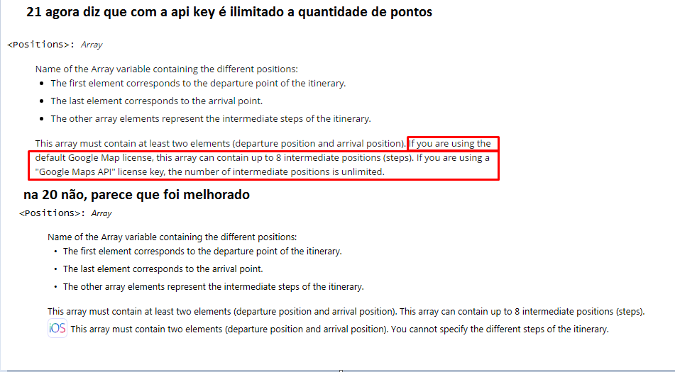
MapAddItinerary, versão 21 ilimitada multi points para rotas
QRY_Menor_Distancia
SELECT
ParticipantesEvento.ParticipantesEventoID AS ParticipantesEventoID,
ParticipantesEvento.Nombre AS Nombre,
ParticipantesEvento.Calle AS Calle,
ParticipantesEvento.Nro AS Nro,
ParticipantesEvento.Ciudad AS Ciudad,
ParticipantesEvento.Pais AS Pais,
ParticipantesEvento.EventoID AS EventoID,
ParticipantesEvento.Sector AS Sector,
ParticipantesEvento.Telefono AS Telefono,
ParticipantesEvento.Celular AS Celular,
ParticipantesEvento.LATITUD AS LATITUD,
ParticipantesEvento.LONGITUD AS LONGITUD,
ParticipantesEvento.DISTANCIA AS DISTANCIA
FROM
ParticipantesEvento
WHERE
ParticipantesEvento.EventoID = {ParamEventoID}
ORDER by
DISTANCIA Asc
Example Multi Points
Procedure WIN_Mapa(gnCodPasajero is 8-byte int)
gPosicionPasajero is geoPosition
arryGeo is array of geoPosition
gDestFinal is geoPosition
gDestFinalMaker is Marker
gDestFinal..Latitude = -0.185570
gDestFinal..Longitude = -78.502635
gDestFinalMaker..Position = gDestFinal
gDestFinalMaker..Image = "map.png"
MapAddMarker(MAP_NoName1,gDestFinalMaker)
MapDisplayPosition(MAP_NoName1,MYPSOITION)
gPosicionChofer is Marker
gPosicionChofer..Position = MYPSOITION
gPosicionChofer..Image = "car.png"
MapAddMarker(MAP_NoName1,gPosicionChofer)
ArrayAdd(arryGeo,gPosicionChofer..Position)
HExecuteQuery(QRY_Menor_Distancia,hQueryDefault,5)
FOR ALL QRY_Menor_Distancia
gPosicionCliente is Marker
gPosicionPasajero..Latitude = QRY_Menor_Distancia.LATITUD
gPosicionPasajero..Longitude = QRY_Menor_Distancia.LONGITUD
gPosicionCliente..Position = gPosicionPasajero
gPosicionCliente..Image = "client.png"
MapAddMarker(MAP_NoName1,gPosicionCliente)
ArrayAdd(arryGeo,gPosicionCliente..Position)
END
ArrayAdd(arryGeo,gDestFinalMaker..Position)
FOR i = 2 TO arryGeo..Occurrence
MapAddItinerary(MAP_NoName1,[arryGeo[(i-1)],arryGeo[i]],itineraryCar,iDarkBlue,70,8)
END
MAP_NoName1..Zoom = 12
ArrayDelete(arryGeo,1)
MapFollowMovement(MAP_NoName1,20,MovimentaMapa)

--
Adriano José Boller
______________________________________________
Consultor e Representante Oficial da
PcSoft no Brasil
+55 (41) 9949 1800
adrianoboller@gmail.com
skype: adrianoboller
http://wxinformatica.com.br/ |
| |
| |
| | | |
|
| | |
| |
Membre enregistré
3 655 messages
Popularité : +175 (223 votes) |
|
Posté le 27 septembre 2016 - 16:25 |
VERSAO 21 OU SUPERIOR
--
Adriano José Boller
______________________________________________
Consultor e Representante Oficial da
PcSoft no Brasil
+55 (41) 9949 1800
adrianoboller@gmail.com
skype: adrianoboller
http://wxinformatica.com.br/ |
| |
| |
| | | |
|
| | |
| |
Membre enregistré
3 655 messages
Popularité : +175 (223 votes) |
|
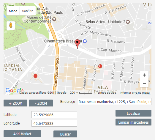
Posté le 25 avril 2017 - 20:33 |
TUTORIAL GOOGLE MAPS
Crie essas variaveis globais
GloVoceEnderecoLongo, GloDestinoEnderecoLongo, GloTempoDestino, GloDistanciaDestino, GloHtmlInstructions, GloPoligonalGoogle are string
GloDistanciaCarro, GloTempoCarro, GloNortelatitude, GloNorteLongitute, GloSullatitude, GloSulLongitute are real
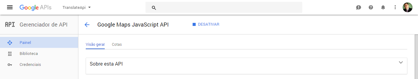
Entre no site do Google API
https://console.developers.google.com/apis/library
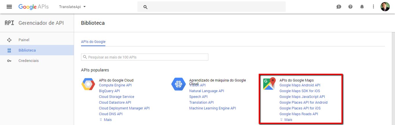
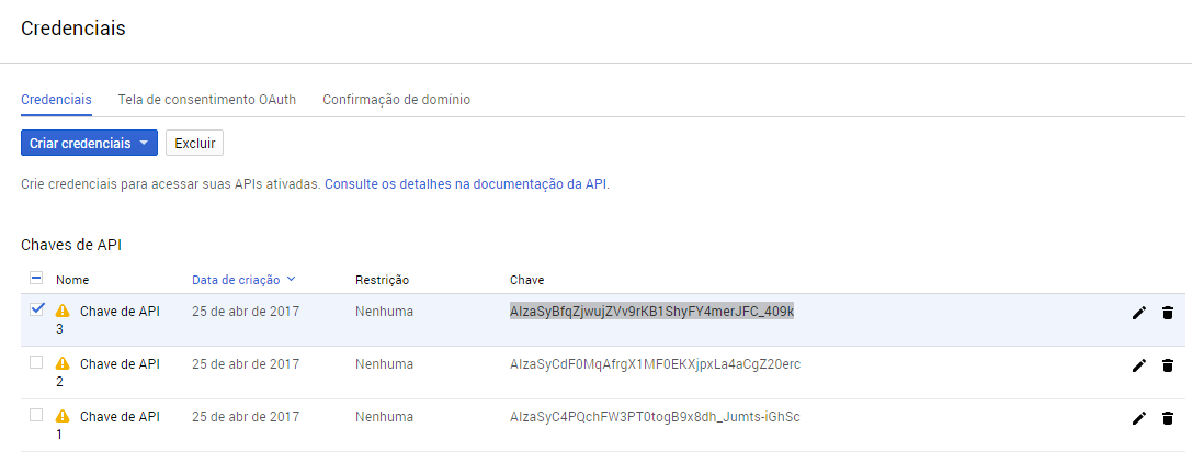
ative e gere a sua chave
Então faça essa tela tanto faz se for no windev, webdev ou no windev mobile:

No open da janela
MapLicenseGgl("AIzaSyBfqZjwujZVv9rKB1ShyFY4merJFC_409k")
---
Botão Buscar()
RotasGoogleMaps(EDT_ENDEREÇO,EDT_ENDEREÇO)
EDT_Latitude = GloNortelatitude
EDT_Longitude = GloNorteLongitute
Info(GloVoceEnderecoLongo, GloDestinoEnderecoLongo, GloTempoDestino, GloDistanciaDestino, GloHtmlInstructions, GloPoligonalGoogle,...
GloDistanciaCarro, GloTempoCarro, GloNortelatitude, GloNorteLongitute, GloSullatitude, GloSulLongitute)
---
Botão Add Market( )
MyPosition is geoPosition
MyPosition..Latitude = EDT_Latitude
MyPosition..Longitude = EDT_Longitude
MyMarker is Marker
MyMarker..Position = MyPosition
MapAddMarker(MAP_Google, MyMarker)
MAP_Google..Zoom = 15
MapDisplayPosition(MAP_Google, MyPosition)
---
Botao + Zoom( )
MAP_Google..Zoom += 5
ToastDisplay(MAP_Google..Zoom,toastLong,vaMiddle,haCenter)
---
Botao - Zoom( )
MAP_Google..Zoom += 5
ToastDisplay(MAP_Google..Zoom,toastLong,vaMiddle,haCenter)
---
Botao Localizar( )
MapDeleteAll(MAP_Google)
RotasGoogleMaps(EDT_ENDEREÇO,EDT_ENDEREÇO)
EDT_Latitude = GloNortelatitude
EDT_Longitude = GloNorteLongitute
MyPosition is geoPosition
MyPosition..Latitude = EDT_Latitude
MyPosition..Longitude = EDT_Longitude
MyMarker is Marker
MyMarker..Position = MyPosition
MapAddMarker(MAP_Google, MyMarker)
MAP_Google..Zoom = 15
MapDisplayPosition(MAP_Google, MyPosition)
---
Botão Limpar market ()
MapDeleteAll(MAP_Google)
---
PROCEDURE PRINCIPAL
Procedure RotasGoogleMaps(enderecoOrigem is string, enderecoDestino is string) : string
IF enderecoOrigem = "" OR enderecoDestino = "" THEN
RESULT(Null)
END
enderecoOrigem = NoSpace(NoAccent(Replace(enderecoOrigem," ","+")))
enderecoDestino = NoSpace(NoAccent(Replace(enderecoDestino," ","+")))
GloVoceEnderecoLongo = "ERRO"
GloDestinoEnderecoLongo = "ERRO"
GloTempoDestino = ""
GloDistanciaDestino = ""
GloHtmlInstructions = ""
GloPoligonalGoogle = ""
GloDistanciaCarro = 0
GloTempoCarro = 0
GloNortelatitude = 0
GloNorteLongitute = 0
GloSullatitude = 0
GloSulLongitute = 0
HTTPCreateForm("GoogleMaps")
HTTPAddParameter("GoogleMaps","origin", enderecoOrigem)
HTTPAddParameter("GoogleMaps","destination", enderecoDestino)
HTTPAddParameter("GoogleMaps","language", "pt-BR")
HTTPAddParameter("GoogleMaps","region", "br")
HTTPAddParameter("GoogleMaps","units", "metric")
HTTPAddParameter("GoogleMaps","key","AIzaSyBfqZjwujZVv9rKB1ShyFY4merJFC_409k")
cMyRequest is httpRequest
cMyRequest..URL = "https://maps.googleapis.com/maps/api/directions/xml"
cMyRequest..Method = httpGet
cMyResponse is httpResponse = HTTPSendForm("GoogleMaps", cMyRequest)
IF cMyResponse..StatusCode <> 200 THEN
RESULT(Null)
END
UrlRota is string = "http://maps.googleapis.com/maps/api/directions/xml?origin="+enderecoOrigem+"&destination="+enderecoDestino+"&sensor=false&mode=driving"
HTTPRequest(UrlRota)
Resultado is string = HTTPGetResult(httpResult)
xmlGoogle is xmlDocument = XMLOpen(Resultado, fromString)
GloVoceEnderecoLongo = xmlGoogle.DirectionsResponse.route.leg.start_address
GloDestinoEnderecoLongo = xmlGoogle.DirectionsResponse.route.leg.end_address
GloTempoCarro = xmlGoogle.DirectionsResponse.route.leg.duration.value
GloTempoDestino = xmlGoogle.DirectionsResponse.route.leg.duration.text
GloDistanciaCarro = xmlGoogle.DirectionsResponse.route.leg.distance.value
GloDistanciaDestino = xmlGoogle.DirectionsResponse.route.leg.distance.text
GloPoligonalGoogle = xmlGoogle.DirectionsResponse.route.overview_polyline.points
GloNortelatitude = xmlGoogle.DirectionsResponse.route.bounds.northeast.lat
GloNorteLongitute = xmlGoogle.DirectionsResponse.route.bounds.northeast.lng
GloSullatitude = xmlGoogle.DirectionsResponse.route.bounds.southwest.lat
GloSulLongitute = xmlGoogle.DirectionsResponse.route.bounds.southwest.lng
Resultado = ""
Contador is int = 1
FOR EACH legNode OF xmlGoogle.DirectionsResponse.route.leg
IF legNode..Name = "step" THEN
HTML is string = legNode.html_instructions
Distancia is int = legNode.distance.value
Resultado += Contador + ". " + HTML + " [" + Distancia + "]" + CR
Contador++
END
END
GloHtmlInstructions = Resultado
RESULT(Resultado)
RESULTADO:
<?xml version="1.0" encoding="UTF-8"?>
<DirectionsResponse>
<status>OK</status>
<route>
<summary>R. Sena Madureira</summary>
<leg>
<step>
<travel_mode>DRIVING</travel_mode>
<start_location>
<lat>-23.5929086</lat>
<lng>-46.6475838</lng>
</start_location>
<end_location>
<lat>-23.5929086</lat>
<lng>-46.6475838</lng>
</end_location>
<polyline>
<points>t~~nCjzu{G</points>
</polyline>
<duration>
<value>0</value>
<text>1 min</text>
</duration>
<html_instructions>Head on <b>R. Sena Madureira</b></html_instructions>
<distance>
<value>0</value>
<text>1 m</text>
</distance>
</step>
<duration>
<value>0</value>
<text>1 min</text>
</duration>
<distance>
<value>0</value>
<text>1 m</text>
</distance>
<start_location>
<lat>-23.5929086</lat>
<lng>-46.6475838</lng>
</start_location>
<end_location>
<lat>-23.5929086</lat>
<lng>-46.6475838</lng>
</end_location>
<start_address>R. Sena Madureira, 1225 - Vila Clementino, São Paulo - SP, Brazil</start_address>
<end_address>R. Sena Madureira, 1225 - Vila Clementino, São Paulo - SP, Brazil</end_address>
</leg>
<copyrights>Map data ©2017 Google</copyrights>
<overview_polyline>
<points>t~~nCjzu{G</points>
</overview_polyline>
<bounds>
<southwest>
<lat>-23.5929086</lat>
<lng>-46.6475838</lng>
</southwest>
<northeast>
<lat>-23.5929086</lat>
<lng>-46.6475838</lng>
</northeast>
</bounds>
</route>
<geocoded_waypoint>
<geocoder_status>OK</geocoder_status>
<type>street_address</type>
<place_id>ChIJzcgV3yBazpQRLAflt-kNk6A</place_id>
</geocoded_waypoint>
<geocoded_waypoint>
<geocoder_status>OK</geocoder_status>
<type>street_address</type>
<place_id>ChIJzcgV3yBazpQRLAflt-kNk6A</place_id>
</geocoded_waypoint>
</DirectionsResponse>
--
Adriano José Boller
______________________________________________
Consultor e Representante Oficial da
PcSoft no Brasil
+55 (41) 99949 1800
adrianoboller@gmail.com
skype: adrianoboller
http://wxinformatica.com.br/Message modifié, 25 avril 2017 - 20:57 |
| |
| |
| | | |
|
| | |
| |
Membre enregistré
3 655 messages
Popularité : +175 (223 votes) |
|
Posté le 25 avril 2017 - 20:53 |
--
Adriano José Boller
______________________________________________
Consultor e Representante Oficial da
PcSoft no Brasil
+55 (41) 99949 1800
adrianoboller@gmail.com
skype: adrianoboller
http://wxinformatica.com.br/ |
| |
| |
| | | |
|
| | |
| |
Posté le 14 février 2018 - 15:33 |
Atenção, o key está comentado, crie o seu key na página correspondente do google maps directions api e substitua, se não, NÃO FUNCIONA ! |
| |
| |
| | | |
|
| | | | |
| | |
|